
Running High, Up the Col de I’Iseran, French Alps
The Col de I’Iseran is the highest paved mountain pass in the Alps, topping out at 2,764 metres (9,068 ft). It runs close to the Italian border, connecting Val-d’Isère in the north to Bonneval-sur-Arc in the south. Yesterday, as my last running act of foolery before turning 46 today, I had a run (slow jog) up it, from where we’re parked in Bonneval.
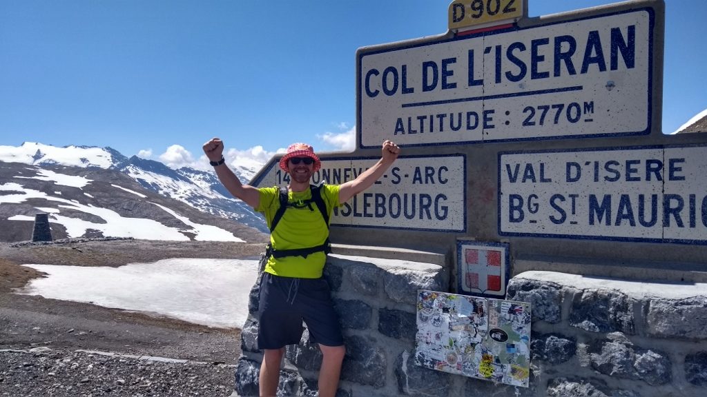
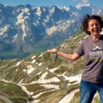
I won’t lie to you, despite the stunning scenery it was a bit of a pig, very hard to keep going up the 8 miles from here to the top, and I was one happy idiot when I finally saw the famous col sign at the top! After I’d got up to it, placed my hand on it, shed a wee tear of relief (it really was hard to keep going!) I called Ju to let her I know I wasn’t dead. A nice local French cyclist, who looked about 70 and was riding an electric bike with no battery attached, took this picture for me:
Topping out on the Col de I’Iseran
Like the Col du Galibier, I did a bit of research before legging it off up there, discovering that:
- The col was closed due to the massive volume of snow last winter, which still wasn’t cleared. We knew this from a lady in Tourist Information, but it was expected to open at any time, so I decided to ignore this fact – something I was lucky to get away with it turns out.
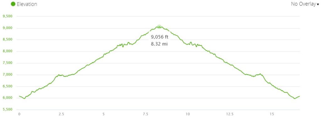
- The route up from here’s steeper and longer than Galibier. According to WikiPedia: “The final 13.4 km (8.3 mi) starts at Bonneval-sur-Arc and rises 977 m (3,205 ft) at an average gradient of 7.3%, with several sections in excess of 10%”. Galibier was closer to a steady 6% in comparison, and was about 3 miles shorter, and about 125m lower in altitude at the top. Gulp.
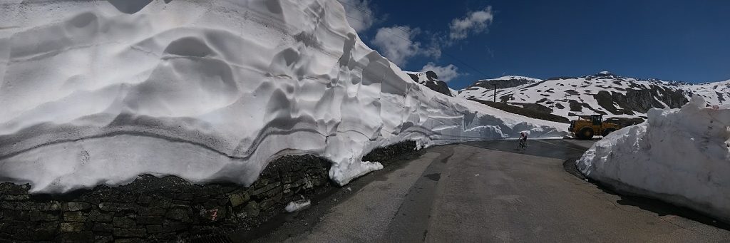
So it was by no means certain I’d be able to get up there, and I went with a ‘I’ll just see how high I can get’ approach. I stocked up on water, figs and some warmer clothes and jogged off out of the village, past the ‘col closed to all traffic, cyclists and pedestrians’ signs and off towards the first hairpin 2km away. Although the road’s closed to traffic at the moment, it’s a decent width with a dotted white line, so should be OK to run up while it’s open if you keep your wits about you. Same goes all the way to the top, although there is a short tunnel and a few narrower cliff-face sections, so high-vis stuff would make sense just in case.
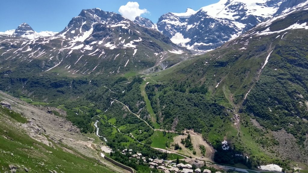
Looking down on Bonneval-sur-Arc at the start of the run – you can just make out where we’re parked – to the left of the village
While edging my way up the road, a few motorbikes came past me, making me wonder if they knew something I didn’t. Maybe the road was open after all? I carried on plodding and they didn’t re-appear, although after about 4 miles the road was blocked with a fence and more ‘don’t come past this point, you fools’ signs, so I guessed they’d moved the fence. I thought about turning around for about 2 seconds before just going around the fence and carrying on running.
A few steep sections were starting to appear now, each a few hundred meters long, and breathing was getting a little difficult on them, shallow and fast. More motorbikes came past and I jogged past a worker cleaning the road, who I expected to tell me to turn around but he just ignored me, so onwards I went. The views were still stupendous, but to be honest the effort to keep going meant they were a little lost on me, as I wrestled with the usual self-suggestions that I aught to give up.
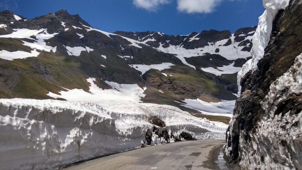
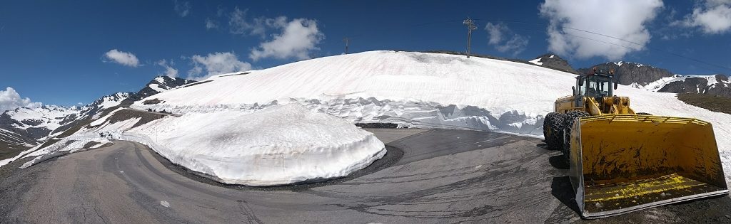
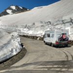
More snow started to appear as I got closer of the top, a metre or two high at the side of the road. In one section I jogged past a series of workers peering up at a very high bank of snow and ice, pointing at sections of it and making brief remarks with each other. They’d blocked the road with a truck, and again I expected to be ushered off back from whence I came, but they just glanced at me and went back to the wall of ice. I edged past the truck, a bit surprised to see a motorhome parked up on the other side, clearly unable to descend the pass any further.
From here I was close enough to the top to know I wasn’t going back unless something forced me to. Further up a small avalanche was being cleared by a massive JCB with all-wheel-chains. A few cars and cyclists were waiting either side of the JCB as it shoved the snow and rock off the road. I stopped for a minute until we could get through, then jogged on past and up to the top, now quite cool compared to the heat of the valley. Breathing became just that little bit harder as the miles went by, but I figured cyclists are going over this col all the time in summer, so it can’t be that extreme as long as you’re fit enough. It turned out to be OK, and I finally rounded a hairpin to see the col sign, with a handful of folks milling around the closed restaurant at the top.
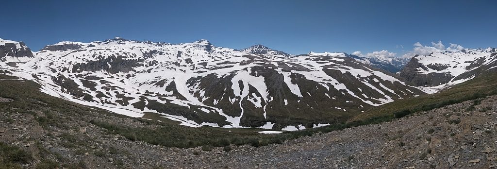
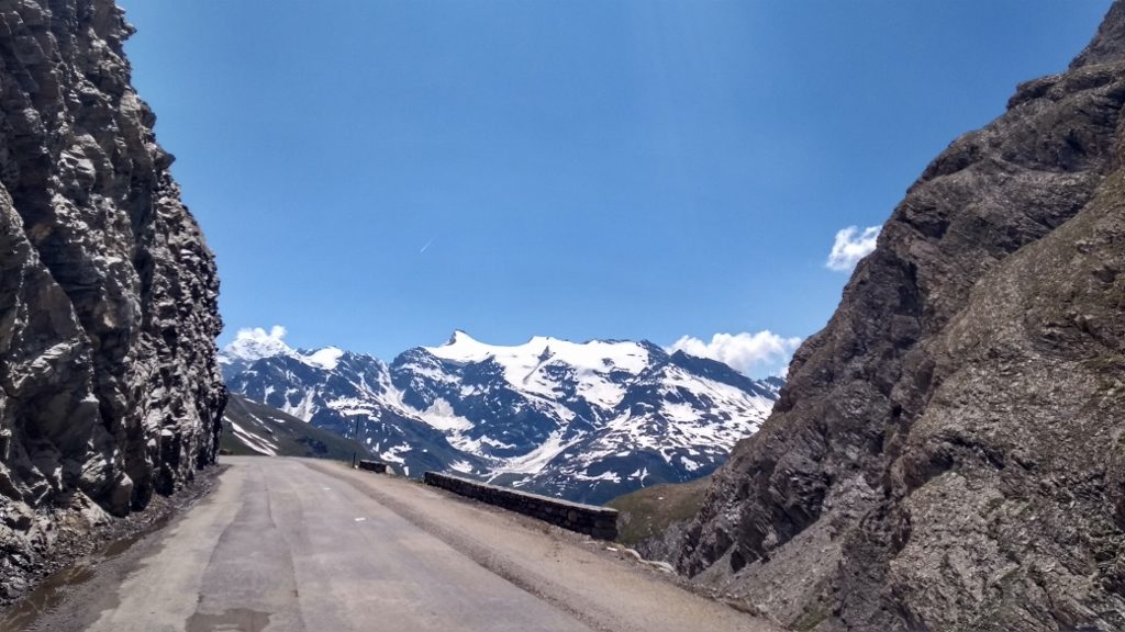
The wonderful view from the col
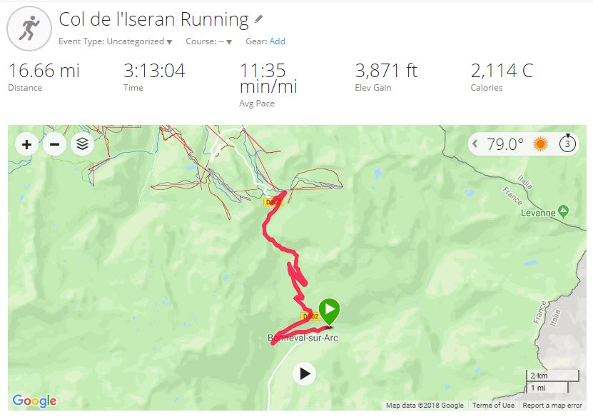
Once I’d got the obligatory photos, I turned round and jogged back down, careful not to go too fast as my right knee’s been a tad dodgy since Galibier. The run back down was easy compared with the run up, and I enjoyed the views all the more. At one point a Polish van came past me, I have no idea how they got past the workmen, and I watched him move the fence below me to complete the pass. Back home, the 16.6 mile run took me 3 hours and 13 minutes and, according to my watch, burned off 2114 calories, making room for a couple of beers and a biscuit. So, that was it. One of the hardest and most rewarding training runs I’ve ever done, phew!
Later that afternoon we learned there’s been a decent-sized avalanche up on the pass, closing it again for several days. A photo of it showed huge blocks of icy snow and rock right across the road, and the report spoke of 3 vehicles which had ‘recklessly’ passed the barriers and become stuck up there. Yes, I did feel guilty and more than a tad relieved that I’d gotten through both unscathed and without causing bother to the locals. Better to not be like me, and wait for the pass to be officially open before attempting it…
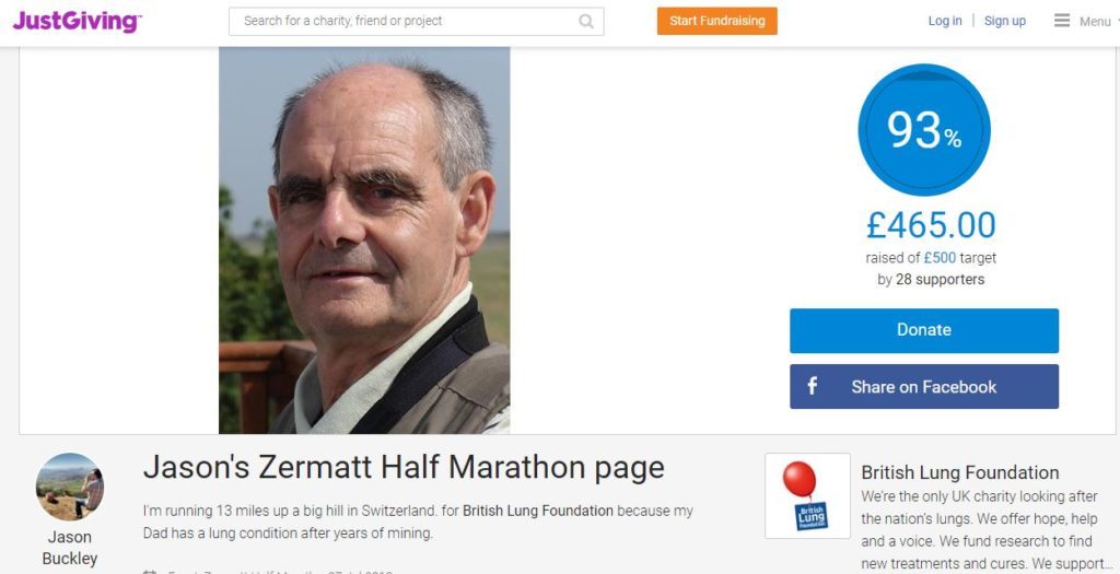
I’m starting to ease off my training now, having done four hilly half marathon runs in 8 days. Zermatt (which will be harder than any run I’ve done in the past 20 years) is just over two weeks away. Bring it on! The sponsorship money for the British Lung Foundation and messages of support all help shove me up these mountains, and mean an awful lot to me. If you’d like to read about what this is all about, or contribute (any amount counts), you can click here or on the screenshot below.
Cheers, Jay


")

The last few posts have been amazing, the views stunning and the training runs incredible! It makes me want to retire now (steady on just under 4 years left until the plan comes together) and leave this sterile office environment. I wish you every success in Zermatt and as we were only there in May last year, I can picture the run ahead of you. Good luck and keep these incredible posts and locations coming! Paul
Thanks Paul, very much appreciated! Jay
Happy birthday 46! I wish you all the best for Zermatt.Keep healthy!
kind regards from Germany Heide from Herne
Thanks Heidi! :-) Jay
By heck lad ! Now that’s what tha call a jog ! Stunning pictures ! Happy 46th from all ere near I’Lson.
Aye! It were woss than Eeenor ‘ill!
Jay, Happy Birthday! Amazing effort, running at this high altitude is incredible. .well done indeed. I am sure you will succeed in Zermatt
Fair play to you, happy birthday, suppose you’ll find a wee bar open today and watch the footie at lunchtime!
What a great birthday present! Beautiful, but looks very tough!