

An Amateur Cyclist on the Combe Laval, Vercors
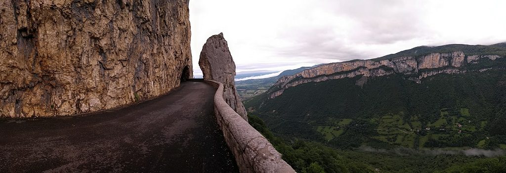
The Combe Laval (described here) is one of France’s incredible balcony roads, routes which it must have taken some serious bravado and one too many ales down le pub to even conceive of back in the 19th century. This particular example’s located on the western edge of the Vercors Massif, just to the south-west of Grenoble in south-east France (a map might have been better at this point…). Being down here in our 3.5 tonne, 3m high, 2.2m wide motorhome, I’d already discounted the idea of driving across the Combe Laval as, although we’re within the limits set for the road, I’d rather cling onto whatever sanity I have for just a wee while longer. It’s a bit tight up there!
The Combe Laval Balcony Road, Vercors, France
The road hugs the heights of a cliff face alongside the top of a monumental gorge, the mouth of which gapes open above St-Jean-en-Royans, where we happily parked up for the night. While there, Ju nipped into tourist info, and came back laden with cycling routes. Route No 28 – Les Grands Cols de Vercours – included the Combe Laval, but was 62km long, estimated at 4 hours, and with 1571m of climbing (a bit less than a vertical mile…).
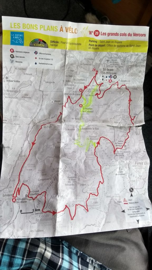
Route #28. I took the highlighted shortcut.
The leaflet stated it was intended for a cyclotouriste habitué, which I am not, having used our £45 second-hand mountain bike all of twice. Fortunately Ju passed my ineptitude on to the tourist info lady, and she marked out a much shorter circular route of maybe 22 miles.
I ask you, do I look like a ‘cyclotouriste habitué’? No, no I do not!
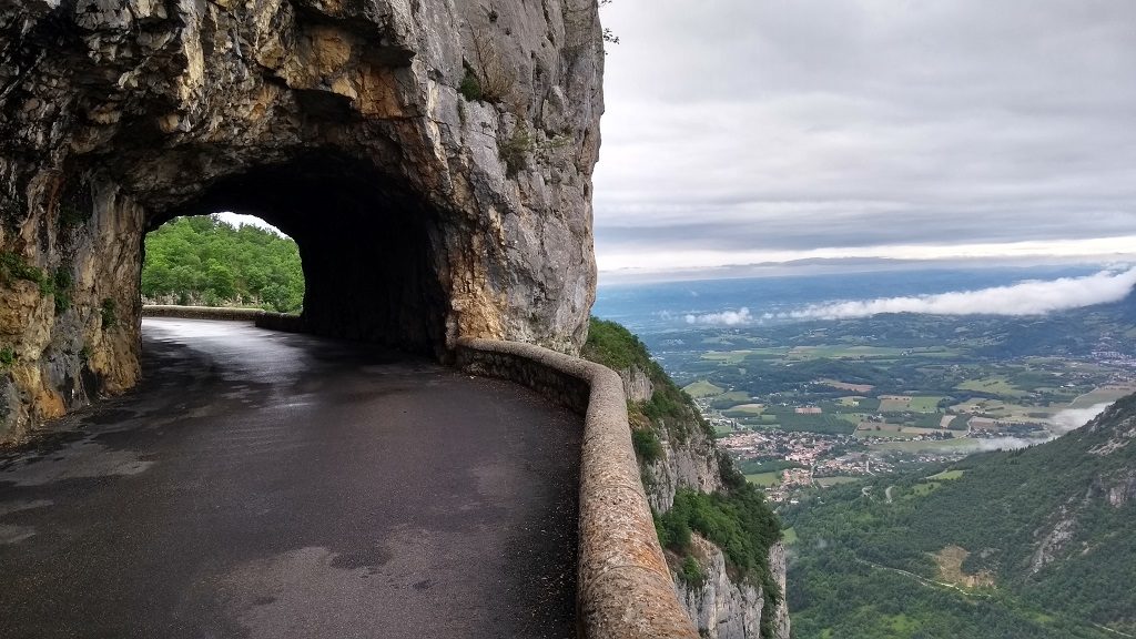
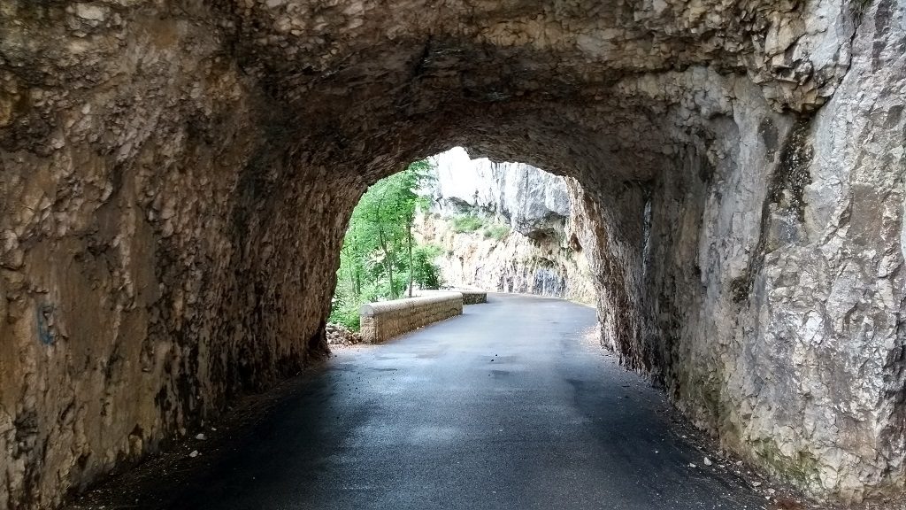
This morning I set off, loaded down with a few litres of water, map, tools, phone, figs to scoff and a long-sleeved top, in case it got chilly (it’s June, it did get a bit chilly on the way down, but not enough to bother with it). The Combe Laval, for me and for most folks I guess, is about the spectacular section right at the gorge mouth, the highest, stupidest, tunneliest, most death-defying bit. If you only want to see that bit, you’ve got about a 6 mile climb, which took me about 70 minutes (not much faster than running it?).
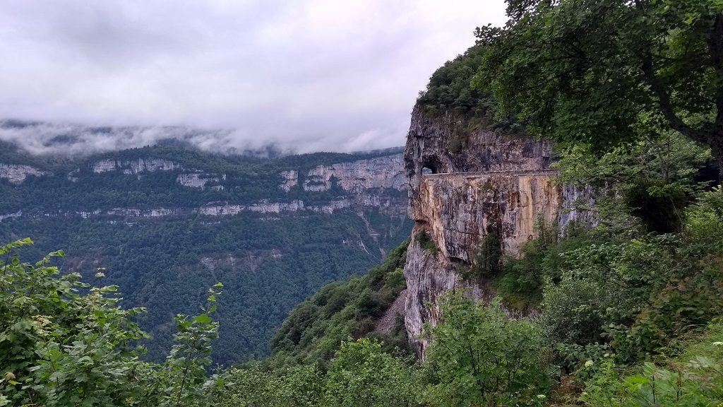
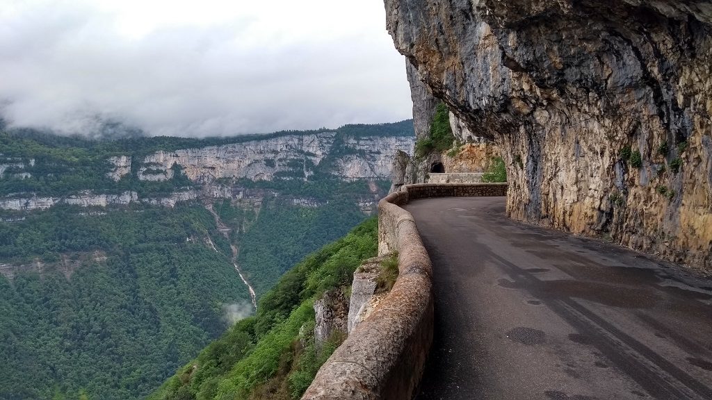
Coming from St-Jean-en-Royans, this is the first view of the cliff road you get. Jaw-dropping stuff.
I say ‘about’ as I completely forgot to look at my watch when the road finally emerged from the trees and the first tunnel framed the open sky off to my left. Jeeze. How, how, how, even with a skinful of beer and several blood-firing face-slaps, did anyone think they could build a road HERE? They did though, some intrepid, dauntless folks thought it up and people tougher than I can even imagine hacked it from the cliff face.
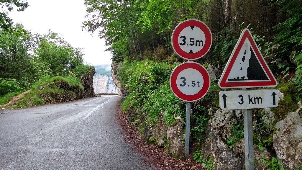
Just around the corner are the height and weight limits. There should be a small sign to say “sigh, look, if you’re anywhere near these limits, best write an impromptu will before continuing”…
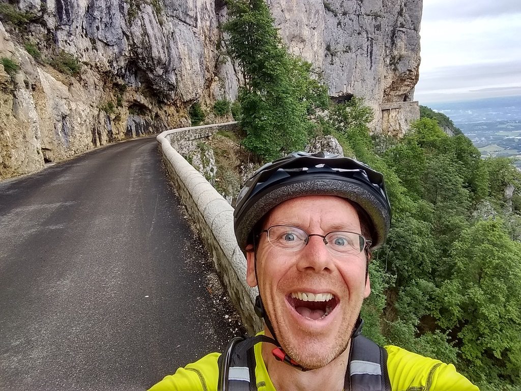
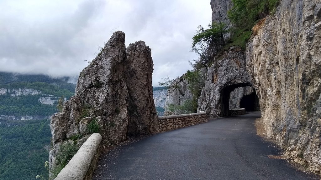
During the night before, I’d woken and imagined going off the cliff face, forced over the low wall by leaning back too far for a stupid selfie-shot, or being rammed into the abyss by an enraged white van man. I’ve not much fear of heights (unless it’s Ju near the edge…), but once up there I have to say I was careful! There was very little traffic to worry about, and plenty of space to lean the bike against the cliff and gawp around the 500m-or-so section of really intense road. Having ridden/walked up and back I got the nerve up to ride along and shoot this video –
From here the road carried on upwards, through more small tunnels before popping out at an eaterie at the Col de la Machine. There’s a good viewpoint here looking out over the forest and cliffs in the gorge, a sticker-splatted sign for the gorge, and weirdly an old ‘many thefts here, don’t leave anything in your car’ sign, right in the middle of nowhere. After a few figs I plodded off up the road, wondering why it was still going upwards from the other side of a ‘col’, which is usually the highest point on a mountain pass.
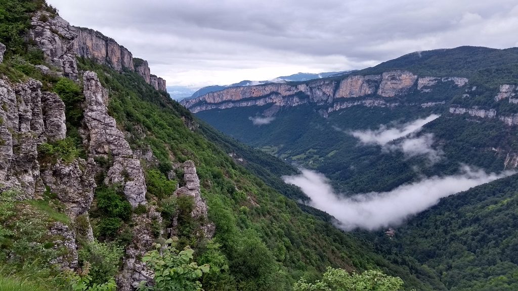
Looking back from Col de la Machine
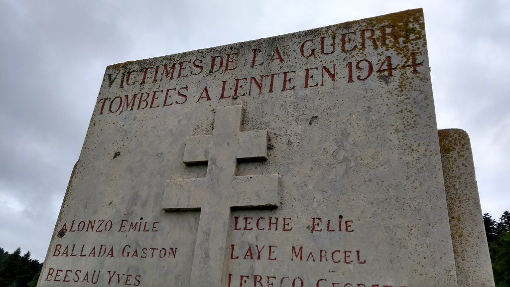
From here the road heads through Alpine forests and farmlands towards the village of Lente. At one point, a small monument stood out above the grass in a field, announcing the killing of resistance fighters in 1944. Just before D-Day, an uprising took place in the Vercors, with encouragement from London. Russian and Ukrainian volunteers in the German army were quickly shipped in to quell it, and the resistance fighters crushed. The monument listed a number of names, and at the bottom: ‘two unknown’, poor bloody fellas.
After Lente the road climbed up to my shortcut turnoff towards Bouvante le Bas. In all about 10 miles of climbing, which to some of the 0% body fat fellas cycling these parts will obviously be nothing, but for me it was enough. The ride back home from that point was almost entirely downhill, grabbing at the brakes, 30mph-for-free stuff, and I loved it!
I was out for maybe 3 hours in the end, including breaks, so the 4hrs for the full loop would more likely have been 6 to 8 for me. That’s the last of the balcony roads for now, having run the Gorges du Nan a few days ago. We drove the Petits Goulets this afternoon, which ends in a large, modern tunnel now that the Grands Goulets is closed. If they ever re-open the Grands Goulets, I think I’d love to see that section too, as it looks pretty amazing, but for now the fences are pretty clear: off limits!
Cheers, Jay
")


")


Wow! No words except well done you! Photos are incredible. So glad we have been forewarned and will double check if we ever come across road signs that lead us to think we’re within size for the road!
I know! The road map is really hard to interpret sometimes, it looks like a normal French D road, which we can use no problem!? Cheers, Jay
Good on you!! I’m very envious. Should I head down there in 3 weeks? I’m fat and unfit but would love to get up onto the big climbs around Grenoble. I’d love to take my full carbon road bike but it’s incredibly thievable from the bike rack, so it may be on my 1997 Mountain Bike (and patiently twiddling up the hills.
3 more weeks of “life getting in the way” and we’ll be heading to Ile de Ré
Lee @ Go Humberto!
Bring your mountain bike, less worry, less bother about it being dirty on the back, the views and air will feel just the same! Hope the last 3 weeks go well. Cheers, Jay
Chapeau!
Amazing pictures again Jay. Well done you cos I know heights are not really your thing x
I think I’ve just discoverd something for my bucket list! Looks amazing!